Nabin K. Malakar, Ph.D.

NASA JPL
I am a computational physicist working on societal applications of machine-learning techniques.

Research Links

My research interests span multi-disciplinary fields involving Societal applications of Machine Learning, Decision-theoretic approach to automated Experimental Design, Bayesian statistical data analysis and signal processing.

Linkedin


Interested about the picture? Autonomous experimental design allows us to answer the question of where to take the measurements. More about it is here...

Hobbies

I addition to the research, I also like to hike, bike, read and play with water color.

Thanks for the visit. Please feel free to visit my Weblogs.

Welcome to nabinkm.com. Please visit again.

Wednesday, May 25, 2016

Special Issue "Sustainability in the Mountains Region"


Mountains are a part of the global biodiversity repository, play a vital role in maintaining global ecosystems, while supporting millions of people. In the meantime, they are the most vulnerable ecosystems. Changes in the environment and economic priorities in past few decades have considerably influenced the livelihood and sustainability of mountains globally. The effects of changing climate and other socioeconomic factors on mountains can affect the densely populated and underdeveloped regions to an inconceivable scale. It is, therefore, important that we study the impacts of climate change, changes in economic priorities of the mountain residents, and increasing non-conventional values of mountain ecosystems and its inhabitants. Moreover, the factors affecting the sustainable livelihood of mountain inhabitants need to be carefully studied to assess the short and long-term impacts, and to develop a long-term strategy for improving the livelihood of the residents in the face of the changes.
This Special Issue will feature peer-reviewed papers from the international conference on “Mountains in the Changing World (MoChWo)”, to be held in Kathmandu, Nepal, on 1–2 October, 2016 (http://conference.kias.org.np). The conference and the Special Issue aim to provide a forum for international/national scholars, researchers, policy makers, and students with an opportunity to share their research findings and knowledge related to various aspects of mountains.  
The range of relevant topics include:
  • Environmental, economic and social sustainability
  • Land use and land cover monitoring, natural disaster and risk assessment
  • Decision making and societal impacts, policy and management strategies for sustainable development
  • Citizen science and trainings
  • Remote sensing, and mapping of resources
  • Data fusion, and data visualization relevant to sustainability issues
  • Innovation in renewable and alternative energy
  • Pesticide uses and sustainable agriculture
  • Organic farming
We welcome papers from broadly defined topics that are relevant to the theme of the Special Issue.
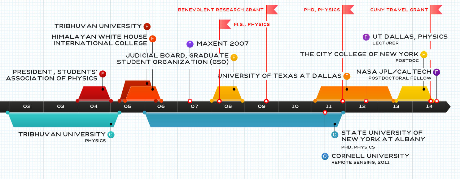
Dr. Nabin K Malakar
Dr. Rajan Ghimire
Dr. Jhalendra Rijal
Dr. Pradeep Wagle
Guest Editors
-->

Friday, April 8, 2016

An Interview with Dr. Mike Abrams, #ASTER project leader @NASAJPL

The Advanced Spaceborne Thermal Emission and Reflection Radiometer (ASTER) instrument has been flying in space on the Terra platform since its launch in 1999. Not bad for a satellite which had an expected lifespan of five-years. Hopefully it will continue into the foreseeable future. The instrument acquires images in visible, near infrared, and thermal infrared wavelengths (TIR). The spatial resolution range from 15 to 90 meters. ASTER spans +- 83 degree latitudes, and covers 99 percent of earth's landmass.  ASTER also produces one of the high resolution elevation dataset (30m).
Recently, NASA released the complete archive (2.95 million images) of Earth's thermal infrared images to the public with unlimited access. Previously, users could access ASTER's global digital topographic maps for free, however, other ASTER data products were available at nominal fee paid to Japan’s Ministry of Economy, Trade and Industry (METI).
ASTER has been used to study, map, and monitor the ever-changing surface of our planet Earth. Some of the products and application of ASTER data include surface mapping and monitoring of changes in surface properties such as glacial advance/retreat, volcanism, crop stress, cloud properties, wetlands, coral reef degradation, land surface temperature, surface geology, etc.

A good selection of ASTER images can be found on the ASTER web site, gallery pages:

The dataset is available at:

We stopped by the office of Dr. Mike Abrams, the project leader for ASTER science team at NASA JPL.
Here are 5 quick questions with him:

1. Please share your experience with the ASTER project.
I have been involved with the ASTER project since its inception in 1988 as part of NASA’s Earth Observing System (EOS) program. Working with my Japanese colleagues and traveling to Japan has been an enriching inter-cultural experience. Added to that is the satisfaction of the success of our 16-year joint mission
2. Why are the millions of ASTER images being made public?
In Japan, oversight of the ASTER project was transferred from one organization to another. The new operator is part of Japan’s National Science Institutes. Jointly, with NASA, the decision was made to eliminate charging for all ASTER data.

3. How can users get maximum use out of the ASTER data?
Natural color, full resolution JPEG images can be downloaded for all images in the archive. No sophisticated software is needed to view these images. (https://lta.cr.usgs.gov/terralook/home). To do more in-depth analyses, the digital data must be downloaded, then analyzed with GIS or image processing software.

4. What are the unique feature of ASTER? (Some examples of news for societal benefit.)
Our high resolution, global Digital Elevation Model (DEM) data set is unique. It is the only topographic data freely available to all users covering the land surface of the Earth at 30m resolution. We have a vigorous monitoring program of 1500+ active volcanoes, and 100,000+ glaciers, looking for time-dependent change. We also acquire many images for post-disaster mitigation, like damage from tsunamis.
5. Do you have favorite image(s) of ASTER?
See the interview with National Geographic: http://news.nationalgeographic.com/2016/04/160406-pictures-nasa-terra-aster-satellites-space-science/

A selfie with Dr. Abrams.
Note: I had an opportunity to be a co-author with him on the paper:
The ASTER Global Emissivity Dataset (ASTER GED): Mapping Earth's emissivity at 100 meter spatial scale, GC Hulley, SJ Hook, E Abbott, N Malakar, T Islam, M Abrams
Geophysical Research Letters 42 (DOI: 10.1002/2015GL065564)
http://onlinelibrary.wiley.com/doi/10.1002/2015GL065564/full 

Thursday, February 11, 2016

Gravitational Waves and LIGO Experiment

One of the fascinating argument of Einsteins' theory of General Relativity can be simply illustrated by the foam-ball diagram. Where a heavy ball put on the surface would produce a curvature. Thereby generating the deformation so that if a lighter ball is rolling nearby, it would cause the ball to roll towards the bigger ball.

Similarly, if we imagine that the space-time that our universe resides is a giant surface in 4-dimension, then we can argue that things that have mass will cause that surface to bend. In other words, the matter will tell the spacetime where to bend while the spacetime curvature will then dictate how the mass will travel.  The more "heavy" the mass, the more bending. Ultimately, the  heavy "mass" or huge Energy, can cause a hole in the fabric of spacetime. That we call the black hole!

What is interesting is that we can imagine traveling from point A to B. If the amount of effort that is required is called as action, then naturally one tends to minimize the action. The most straightforward way to minimize the action in two dimension is a straight line! Now, if you were in four dimension, and wanted to go from point (need to call it a four-point as it has four co-ordinates) A to point B. Then naturally, it would be a "straight" line in 4D! However, the manifestation of the space and time makes it look like a curved line near the "heavy" masses. That's the reason behind the orbits of the planets. You may ask: but, aren't the planets coming back to the same positions after one planetary year? Yes, that is right in space. But in time, you moved one year's worth of journey! Think about it!
That means there is no force which is pulling things around. It is just the manifestation of the bending of the spacetime fabric.

When  masses accelerate, gravitational waves are produced. This can cause "ripples" in the space!
The LIGO experiment, (LIGO: The Laster Interferometer Gravitational-Wave Observatory) was designed in 1992. It is a large-scale physics experiment to detect gravitational waves. It consists of 4 km long tunnels in L-shape. LASER interferometry is used to detect any change in the fabric of space due to the gravitational wave. Interferometry go about finding changes in the distance between the points A and B by using the principle of superposition of the waves, by measuring the change in the fringes due to shifting of the reflecting mirrors for example.  This works because when two waves with the same wavelength/frequency meet, their fates are determined by the phase difference between the waves. The waves in phase will undergo constructive interference and the out-of-phase will undergo destructive interference [See this video: https://www.youtube.com/watch?v=J_xd9hUZ2AY More specifically this one : https://www.youtube.com/watch?v=oUytkiBwXvI]. 

In the case of LIGO experiment, the primary interferometers consist of mirrors suspended at each corners of the L-shaped vacuum tube (4km long). A LASER beam is used to monitor the interference patterns called fringes. When a gravitational wave passes through the interferometer site, the fabric of spacetime is affected. Since the instrument is L-shaped, one side will be stretched while the other side is compressed. This changes the phase of the reflecting waves causing the phase difference between the ends of the L-tube, and thus the wave should be detected!!! 
The LIGO has to detect the distortion of 10^(-18) m in space for the light that reflects off the 4-km long tunnel! This is the length less than one thousandth of the diameter of a proton (fm=10^-15). Moreover, since there are two LIGO experiment sites(46°27′18.52″N119°24′27.56″W and
30°33′46.42″N90°46′27.27″W), triangulation method can be used to find the source of the ripple!
Here is a nice video explaining the method


Now here comes the big news!

LIGO has detected the gravitational wave!!!
The authors claim that the signals came from two merging black holes, each about 30 times the mass of our sun, lying 1.3 billion light-years away.
The scientific paper is here:

If you are interested in the press release,
https://mediaassets.caltech.edu/gwave#graphics

FYI: India is working on next LIGO experiment
https://www.ligo.caltech.edu/page/ligo-india

Also, it seems like Einstein had doubt about the Gravitational waves at some point
http://scitation.aip.org/content/aip/magazine/physicstoday/article/58/9/10.1063/1.2117822

One interesting presentation
https://www.youtube.com/watch?v=ajZojAwfEbs


Disclaimer: These are my personal notes. Please draw conclusions at your own risk.